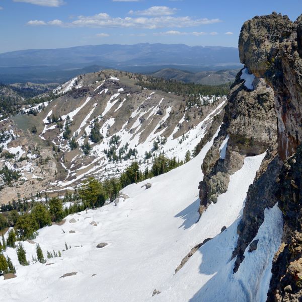
Castle Peak
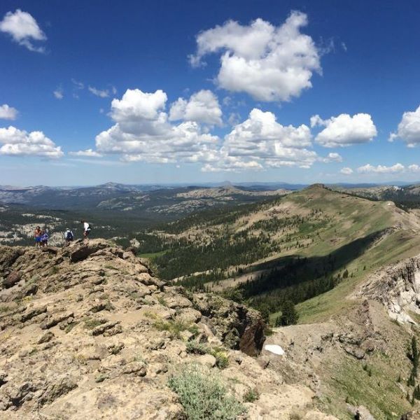
As you drive east on I-80 towards Truckee, one of the most striking features in the Donner Summit area is Castle Peak. Rising proudly to a height of 9,103 feet, this majestic mountain boasts three distinct turrets that dominate the surrounding landscape. Its name is fitting; and it’s no wonder that Castle Peak is one of the most popular hiking destinations in the Donner Summit and Lake Tahoe area.
A Late Bloomer
Due to its high elevation, portions of this hike can remain snow-covered until early July, making it one of the latest spring hikes to open in the region. The peak itself is the glaciated remains of an old volcano, overlying the granite block which dominates the Sierra farther south. At the seam between the volcanic rock and granite you may find springs feeding streams and meadows adorned with wildflowers. From the summit on clear days, enjoy breathtaking views of Mount Diablo in the Bay Area, the Coast Range to the west, Mt. Lassen to the north, and Mt. Rose and the mountains encircling Lake Tahoe to the southeast.
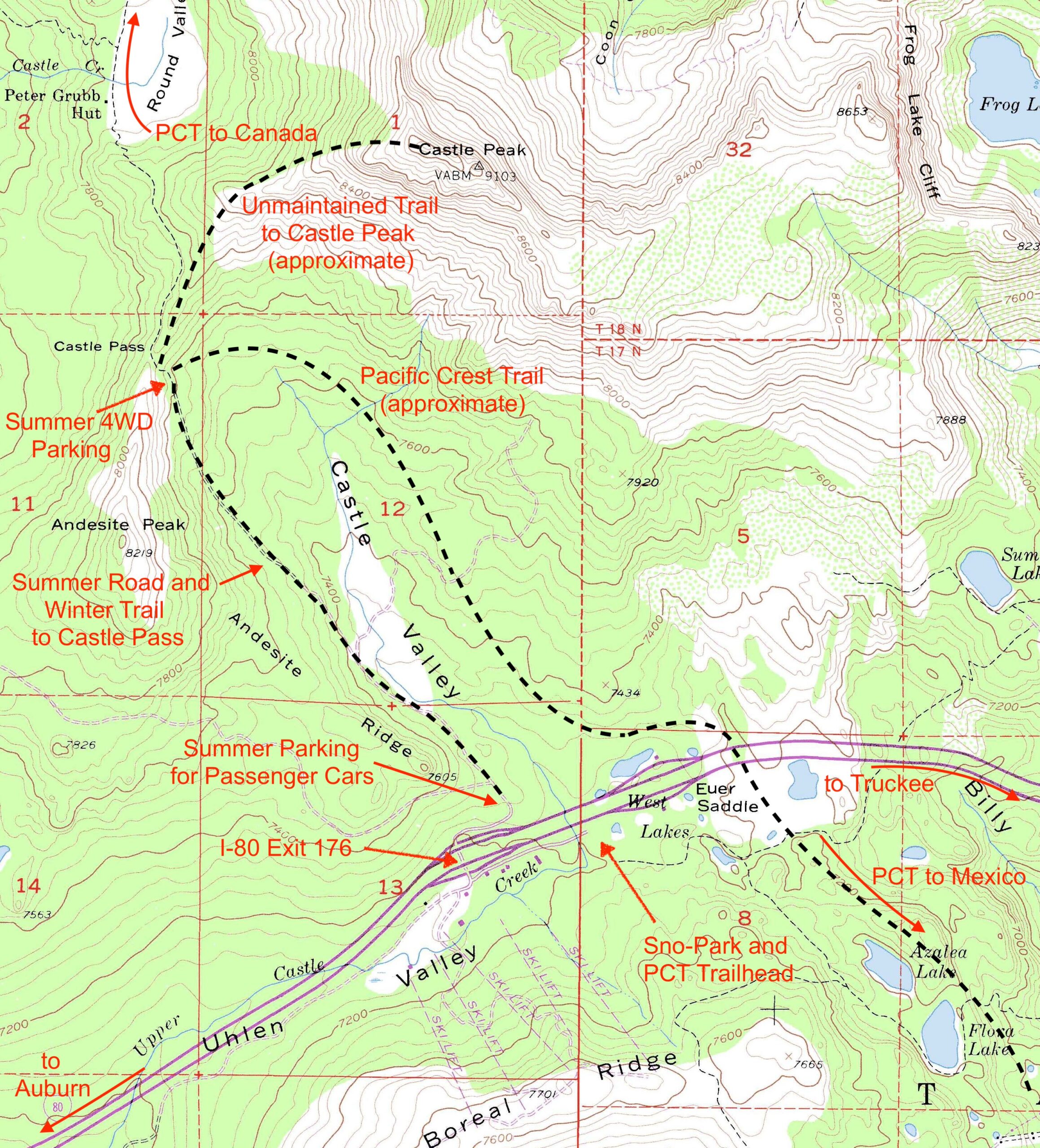
Map created by Dick Simpson
The Route
From the north side of I-80 at exit 176, follow the frontage road east until the pavement ends and the road turns north. Most people park here, but your high-clearance vehicle may be able to go along the west side of Castle Valley to additional parking at the base of Castle Pass. Climb to the top of Castle Pass, then head northeast along the ridge, following unmaintained trails to the top of the northwest turret. This turret is a walk-up, but watch for loose rocks on the way up. The middle turret is more difficult; and the southeast turret is most difficult, requiring rock climbing skills.
Don’t Need To Hike To The Top
If reaching the top isn’t in the cards, you can still have an enjoyable outing. From Castle Pass, continue a short mile north along the Pacific Crest Trail (PCT) to historic Peter Grubb Ski Hut, constructed in 1938-39. Owned by the Sierra Club, this charming hut, nestled on the west side of Round Valley, has been a source of delight for visitors year-round. To find out more about the hut or to reserve an overnight spot, visit the Clair Tappaan Lodge’s Peter Grubb Hut page.
Other Hiking Options
While many choose to climb Castle Peak, there’s a whole network of other trails in the area. A portion of the 2,650-mile Pacific Crest Trail passes through this area, offering access to spectacular terrain. A PCT trailhead on the south side of I-80 at exit 176 connects south to Lakes Azalea and Flora and to the original Donner Pass Road. In the northward direction the PCT connects to Frog Lake Overlook, its breathtaking cliffs towering above Frog Lake, and to Warren Lake. If you want a more forested route to Castle Peak, take the PCT north to Castle Pass at a cost of 1-2 additional miles in each direction compared with the more conventional route along the west side of Castle Valley.
A Backcountry Mecca for Winter Recreation
As snow blankets Donner Summit, Castle Peak becomes one of the most popular places for backcountry skiing, snowshoeing, and snowboarding. The peak offers descents westward into Round Valley and southward into Castle Valley, leading back to the interstate. With the arrival of spring, the expansive south-facing snow apron beneath the main rock buttress provides ideal conditions for classic spring skiing on its sun-kissed slopes. In mid-winter, the north side of the ridge boasts some of the finest ski terrain in the region. The same trailhead also serves as a popular starting point for snowmobiles, which must stay to the west after the first 100 yards.
Know Before You Go
Before embarking on your winter adventure, note that snow-cleared recreational parking is available only in the California Sno-Park at I-80 exit 176. Camping is prohibited as per Forest Order 17-22-06. Adjacent land is privately owned, and recreational use is strictly prohibited. It’s advisable to have a backup plan in case parking at the Sno-Park is full.
PARKING PASS REQUIRED NOV 1 – MAY 30: $15/day or $40/season. Passes sold on site during weekends.
Directions
The summer parking area for Castle Peak is on the north side of I-80 at exit 176. To reach the PCT trailhead in summer, go to the south side of I-80 at exit 176, then turn east and follow the frontage road to parking. In winter, follow the directions to the PCT trailhead and display your Sno-Park permit after you park.