
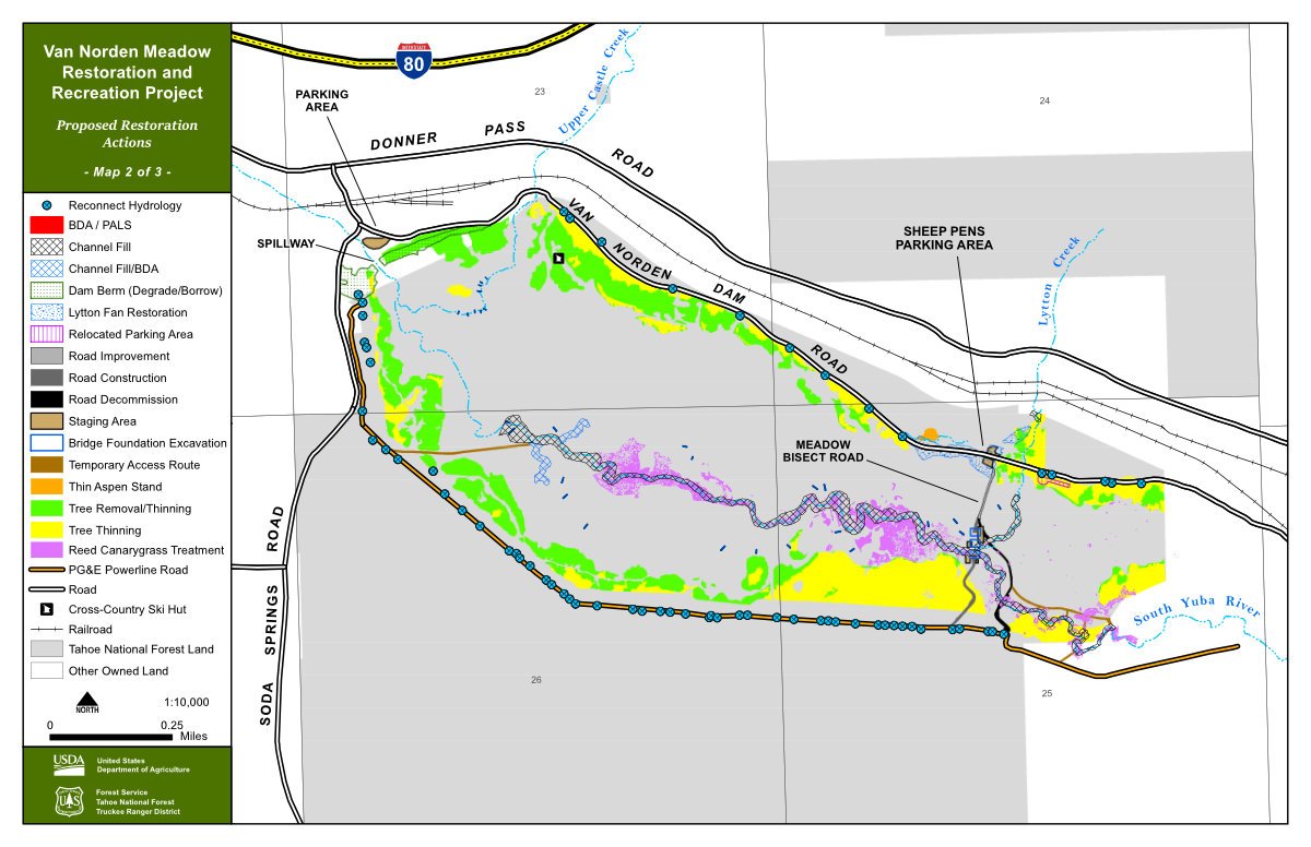
Meadow Restoration

There was a lot of activity in Van Norden Meadow (also known as Summit Valley and, in Washoe, as Yayalu Itdeh) from August trough October 2022. That activity was the first of at least three phases of restoration (Map2 Restoration) and recreation upgrades (Map3 Recreation) to ‘reset’ the Meadow to something like its condition before Europeans arrived and then to make it more accessible to visitors. The work is being managed by the South Yuba River Citizens League (SYRCL) in cooperation with Tahoe National Forest (TNF) which is the landowner.
Over the past 150 years roads, excavation, and human ‘management’ have changed the drainage. Because water traveled in deeply eroded channels, the ground water level dropped. This had the effect of drying the meadow sooner than in previous centuries. Plants with shallow roots dried earlier; and lodgepole pines, which favor drier soils, encroached from the Meadow edges.
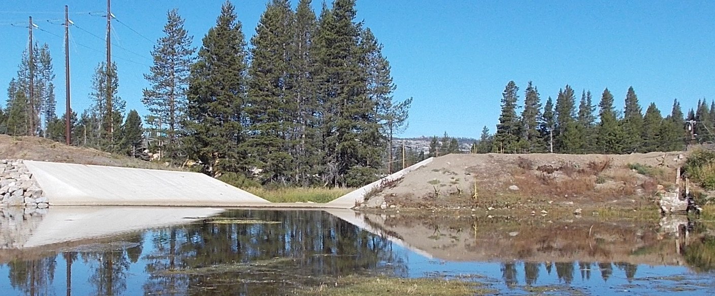
Van Norden Dam. The berm on each side was reduced to the wings of the new spillway.
Grading on the dam berm and in the Meadow began in late August 2022. Work continued to mid-October, then ended before the first snow on November 1.
Phase I of the restoration included removal of the original spillway (near Soda Springs Road and the PG&E substation), the Van Norden Dam berm (which was cleared of trees in 2021), and some dense thickets of lodgepole pine that have encroached on the original Meadow since the dam was breached and Lake Van Norden was reduced in the mid 1970s. The dam berm, but not the current spillway, was trimmed to the Meadow’s elevation and the material removed was used to fill the Yuba River and Lytton Creek channels. Lowering of the dam, as a by-product, gives travelers on Soda Springs Road a better view of the Meadow.
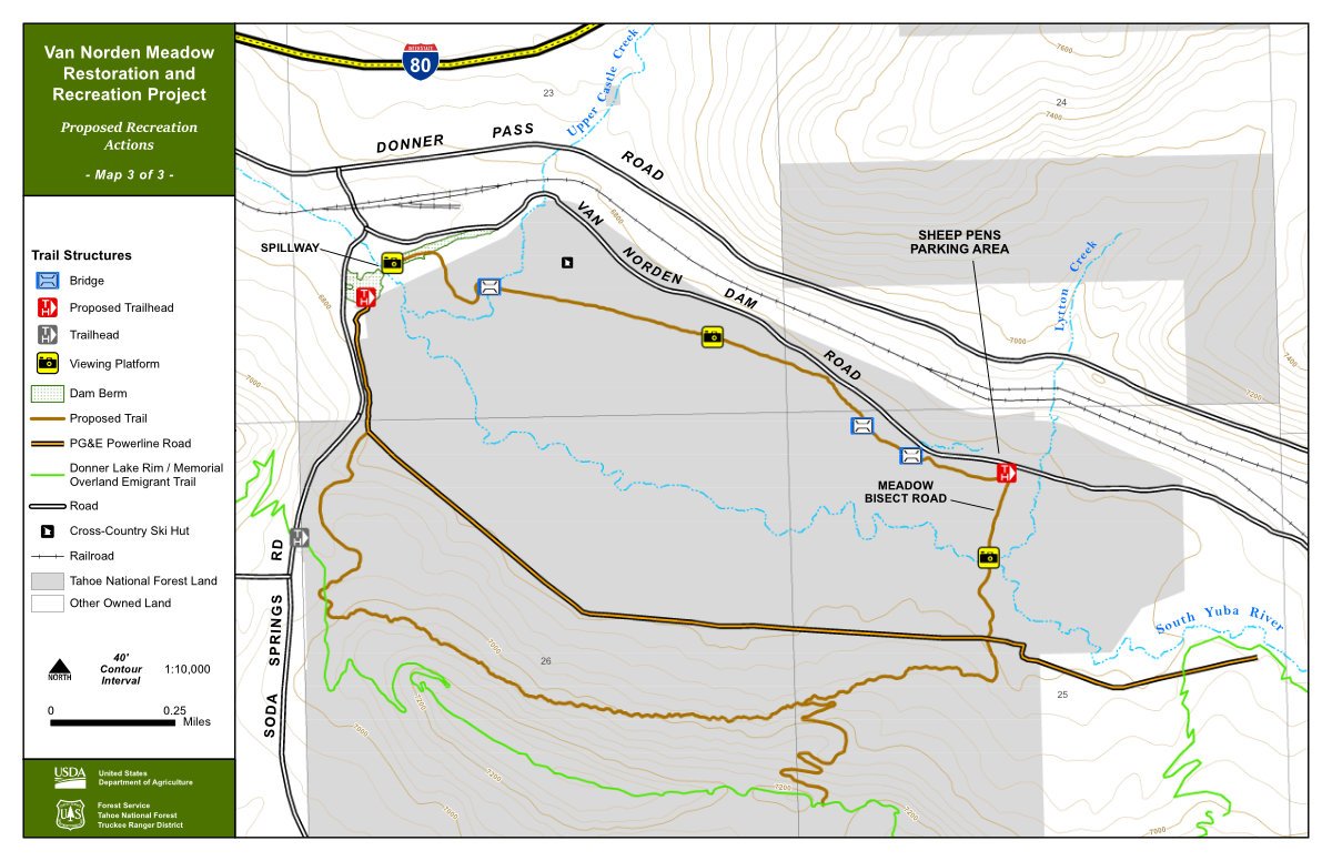
At the east end of the Meadow the narrow bridge was removed; a new wider bridge, which can accommodate grooming machines, was installed a short distance upstream. The road to the bridge was improved although it will remain closed to public vehicle traffic. Invasive reed canary grass was buried or removed from the channels and willow stakes were planted to reduce erosion during the 2023 melt and runoff.

Anchored bundles of willow stakes will reduce erosion during future melt and runoff cycles.
Phase II will begin in late 2024 thanks to a $2.5M grant to SYRCL from California’s Department of Fish and Wildlife. The outflow fan into the meadow from Lytton Creek will be restored. That flow has been interrupted by several incarnations of Donner Pass Road, the railroad, and culverts. This will return the natural flow of water across the meadow to the Yuba from one of its main high-altitude tributaries. The parking area at the Sheep Pens will be moved east to further enable the natural flow of water. By 2025 there will be vault toilets and signage at the parking area,.

Excavation of the original spillway and reduction of the dam have left an area which may be developed as a visitor facility and trailhead. The PG&E substation is to the right (out of the picture).
Phase III may also include construction of a parking area near the PG&E substation. Eventually this will become a new USFS trailhead with bathrooms; but these are recreation enhancements and are not part of the currently funded restoration.
Field work is being done to measure things like water table depth so that the project’s progress and success can be monitored and compared against base values measured before Phase I. Rain on snow events will be monitored to ensure that deluges of water are not simply digging new channels. If the project does not seem to be accomplishing the plan’s objectives, changes will be made. As of early 2024, and after the heavy winter of 2022-23, the objectives of Phase I appear to have been largely accomplished.
The purpose of the project is to slow water as it moves across Van Norden Meadow to the Yuba River and then down the Yuba. With the filling of current stream and river channels, water ‘sheets’ over the meadow and the current small swales slow the water’s movement. This sheeting is a matter of inches rather than feet. That leaves the meadow wetter longer into the summer, keeping grasses, sedges, and similar plants alive longer. Making the surface of the meadow wetter will also help stop the encroachment of lodgepoles. If the project design doesn’t slow water enough, beaver analogs — man-made structures that mimic beaver dams — will be constructed. Some have already been put into place.
Some raise the issue of flooding downstream if there is no water storage capacity, as there was with Van Norden Dam. Modeling shows that water traveling across the restored Meadow will slow since it won’t be going down the eroded channels; the time difference is about twelve hours, which should buffer the immediate downstream area.
Other work includes formalizing trails and adding signage. The remains of the Dutch Flat Donner Lake Wagon Road will become part of a trail around the meadow. As mentioned above, bathrooms will be added at both the new Sheep Pens and West End parking areas. Recreation will be balanced against archeology in the area — that is, the Native American grinding rocks, basalt chips, and other artifacts. Eventually the Forest Service will allow educational and historical activities, such as visiting school groups.
There will be volunteer opportunities. In late 2023 there were willow staking and revegetation events which drew dozens of volunteers. Willows are critical to wetland function and wildlife habitat. There may be opportunities for more willow staking and possible construction of beaver dam analogs in future years
Major funding for the project has come from (in order of contribution): Wildlife Conservation Board, California Department of Fish and Wildlife, Martis Fund, Placer County Tourism Master Plan, Tahoe National Forest, and National Fish and Wildlife Foundation.
For more information about these activities, you may contact project manager:
Alecia Weisman, River Science Project Manager
alecia@yubariver.org
South Yuba River Citizens League
313 Railroad Ave Suite 101, Nevada City, CA 95959
(530) 265-5961 x 224
This article was adapted from material provided by Alecia Weisman and Bill Oudegeest, published by Bill in issues of Ice Lakes News. Photos by Dick Simpson. USFS planning documents may be found at https://usfs-public.app.box.com/v/PinyonPublic/folder/159176148214.